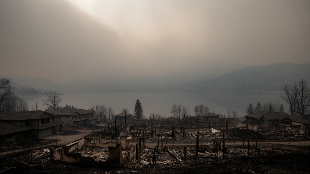
The Okanagan region of British Columbia is currently grappling with a landscape-altering disaster as extreme wildfire activity has decimated residential areas along the shores of Okanagan Lake. Fueled by ferocious wind gusts reaching 115 km/h, the fires have moved with unprecedented speed, jumping containment lines and forcing emergency evacuations for thousands of residents across the Central Okanagan. The rapid escalation of the fire front has transformed quiet lakeside communities into scenes of devastation, overwhelming local emergency resources and prompting a coordinated provincial response.
Key Highlights
- Extreme Weather Catalyst: Gusts of 115 km/h turned standard fires into a high-intensity firestorm, allowing flames to jump Okanagan Lake and compromise residential perimeters.
- Mass Evacuations: Thousands of residents in West Kelowna and surrounding areas have been placed under evacuation orders, with many forced to abandon homes on short notice.
- Infrastructure Loss: Significant structural damage has been confirmed, with lakeside residences and key infrastructure facilities falling victim to the encroaching blaze.
- Provincial Response: The BC Wildfire Service, alongside local fire departments, is managing a complex, multi-front suppression effort amid deteriorating air quality and visibility.
The Okanagan Firestorm: Anatomy of a Climate Emergency
The Night the Sky Turned Orange
For residents in the Central Okanagan, the transition from a standard summer day to a state of emergency was near-instantaneous. The combination of prolonged drought and the sudden arrival of 115 km/h winds created a “firestorm” effect, a meteorological phenomenon where the fire generates its own localized weather, drawing in oxygen and accelerating the rate of spread. Eyewitness accounts describe a wall of fire approaching residential neighborhoods, effectively cutting off escape routes and forcing the BC Wildfire Service to rapidly pivot from suppression tactics to evacuation and protection of human life.
The Meteorological ‘Perfect Storm’
Experts are pointing to the unique topography of the Okanagan Valley as a significant factor in the severity of this event. The valley acts as a funnel for air currents, and the presence of dry, unseasonably warm weather had pre-conditioned the region’s timber. When the high-velocity wind event hit, it did not just push the fire; it lofted embers miles ahead of the main front, igniting spot fires that rapidly coalesced into larger blazes. This behavior made traditional firebreaks largely ineffective, as the embers crossed the expanse of Okanagan Lake, challenging the notion that water bodies serve as natural barriers to fire spread.
The Urban-Wildland Interface Crisis
This event has reignited the national conversation regarding the urban-wildland interface (WUI). As development pushes further into forested areas, the density of residential homes creates a high-fuel environment that is difficult to protect. The loss of lakeside homes highlights a critical vulnerability: many properties in the region are situated within terrain that is historically prone to fire but has seen increased human occupancy. Urban planners and fire safety experts are now forced to re-evaluate building codes, vegetation management programs, and the feasibility of maintaining residential clusters in high-risk zones.
Economic and Social Aftermath
Beyond the immediate physical destruction, the economic repercussions are substantial. The Okanagan is a pillar of British Columbia’s tourism and viticulture sectors. With the evacuation of thousands and the destruction of tourism-dependent infrastructure, the regional economy faces a prolonged period of recovery. Small businesses, particularly those reliant on the summer tourism season, are facing total revenue loss. Furthermore, the psychological toll on the community—the trauma of displacement and the loss of personal history in the form of family homes—will necessitate long-term mental health support services as the region begins the slow process of rebuilding.
Future-Proofing and Climate Adaptation
Looking forward, the BC government and local municipalities face the urgent task of “future-proofing” the region. This involves shifting from a reactive suppression model to a proactive management strategy. This includes aggressive thinning of forests near residential perimeters, investing in fire-resistant construction materials for new builds, and implementing sophisticated early-warning detection systems powered by AI and satellite imagery. Climate scientists emphasize that as the climate continues to shift, high-intensity events like this may become the new normal, requiring a complete overhaul of how the province handles fire safety.
FAQ: People Also Ask
Q: What is the current status of the evacuations near Okanagan Lake?
A: Authorities have issued widespread evacuation orders and alerts. Residents are advised to monitor the Central Okanagan Regional District official channels and the BC Wildfire Service dashboard for real-time updates, as conditions remain fluid and highly dangerous.
Q: Why were these specific wildfires so difficult to contain?
A: The containment difficulty was primarily driven by 115-km/h winds and extreme fuel dryness. These winds caused the fire to jump geographical barriers like Okanagan Lake, creating multiple new fronts that overwhelmed suppression resources.
Q: How can residents protect their properties in high-risk zones?
A: The BC FireSmart program recommends clearing “fuel” (dry leaves, debris, woodpiles) within 1.5 meters of the home, pruning trees to remove low branches, and utilizing fire-resistant building materials like metal roofing and non-combustible siding to reduce the ignition risk during ember showers.