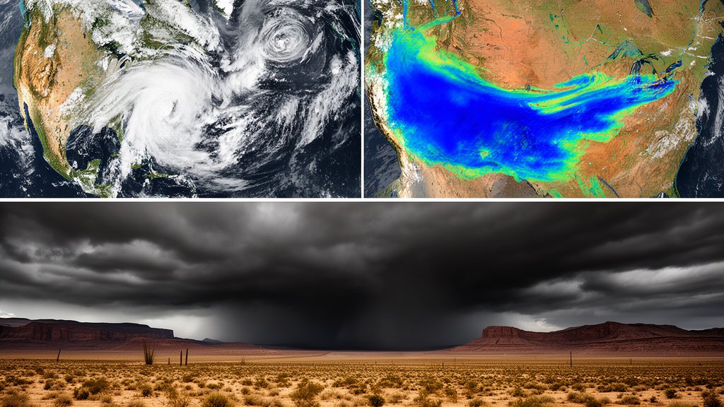
This weekend, the United States is facing a complex and dangerous meteorological landscape, with severe weather threats simultaneously impacting opposite sides of the country. From the aggressive cyclogenesis of a Nor’easter along the Atlantic seaboard to the moisture-laden, life-threatening approach of Category 5 Hurricane Polo in the Pacific, millions of Americans are in the path of a dual-coast hazard. The National Weather Service (NWS) has issued a series of warnings as atmospheric instability creates a high-risk environment for infrastructure, travel, and public safety.
Key Highlights
- Category 5 Threat: Hurricane Polo is tracking toward Baja California, with the National Hurricane Center (NHC) warning of a significant moisture plume expected to cause catastrophic flash flooding across the U.S. Southwest.
- Atlantic Nor’easter: A rapidly intensifying low-pressure system is battering the East Coast, bringing sustained high winds, coastal erosion, and significant power grid risks.
- Travel Disruption: Airline hubs in the Northeast and logistics routes in the Southwest are bracing for rolling delays as the two weather systems converge to dominate the national transport landscape.
- Southwest Flash Flood Risk: NWS offices in Arizona and New Mexico are warning that the influx of tropical moisture could result in 3-5 inches of localized rainfall in typically arid regions.
- Infrastructure Preparedness: FEMA and local emergency management agencies have prepositioned assets as the combined threat level reaches a critical threshold for the weekend.
The Atmospheric Convergence: A Coast-to-Coast Crisis
The synchronization of these two massive weather events represents a significant challenge for emergency management and meteorological forecasting. The atmosphere is currently exhibiting a pronounced wave pattern, allowing for the rapid intensification of the East Coast Nor’easter while simultaneously facilitating the northward movement of tropical moisture from Hurricane Polo. This creates a “pincer movement” of severe weather that effectively traps the central U.S. in a state of high alert, as the ripple effects of both systems will likely disrupt continental supply chains and energy distribution networks.
The Anatomy of the East Coast Nor’easter
Meteorologists are tracking a classic, yet exceptionally potent, Nor’easter. This system is fueled by a sharp temperature contrast between the unseasonably cold continental air mass and the warmer, moisture-rich Atlantic waters. The pressure gradient is tightening rapidly, leading to wind gusts exceeding 60 mph along the coastline. This is not merely a rain event; the coastal impact is expected to include significant storm surge during high tide, threatening low-lying infrastructure. Coastal erosion is a primary concern, with local authorities issuing mandatory advisories for vulnerable barrier islands. The combination of wind and saturated soil also presents a high probability of tree failures, which directly correlates to widespread, extended power outages for the Northeast corridor.
Hurricane Polo: A Moisture Plume for the Southwest
While the East deals with wind and surge, the Pacific Coast faces the devastating potential of Hurricane Polo. As a Category 5 storm, Polo is among the most intense cyclones to track near the Baja California peninsula this season. The danger here is less about direct landfall—though that remains a distinct possibility—and more about the “atmospheric river” effect. This long, narrow region in the atmosphere is transporting an immense volume of precipitable water from the hurricane directly into the U.S. Southwest. For regions like Arizona, southern California, and New Mexico, the ground is often too hard-packed to absorb rapid, heavy rainfall. This leads to instantaneous runoff, turning dry washes into dangerous torrents. NWS data indicates that just two hours of heavy rainfall could trigger flash floods that threaten roads, bridges, and housing developments.
Secondary Angle: Economic Impact and Supply Chain Vulnerability
The simultaneous nature of these storms highlights the fragility of the modern U.S. logistics network. The Northeast is home to major air cargo hubs and shipping ports that serve as the entry point for critical goods. When a Nor’easter triggers ground stops, the ripple effect is felt globally within 24 hours. Conversely, the Southwest is a critical corridor for transcontinental trucking. Flash flooding in this region acts as a localized choke point, forcing the rerouting of freight traffic and increasing fuel costs. Economists at the Department of Transportation are monitoring the situation, noting that extended storm events often result in a 2-4% decrease in quarterly logistics efficiency for the affected regions, an impact that can cascade into consumer markets by the following week.
Secondary Angle: Historical Precedents and Climate Volatility
Climate researchers are paying close attention to the timing of this dual-coast event. While hurricanes in the Pacific and Nor’easters in the Atlantic are not uncommon in isolation, the concurrent intensity is a point of concern. Historical data from NOAA suggests that as global sea surface temperatures rise, the frequency of “atmospheric teleconnections”—where weather patterns in one ocean influence the other—may be increasing. This event provides a real-time study for meteorologists to understand how anomalous heat in the Pacific, which likely fueled Hurricane Polo, correlates with shifts in the jet stream that facilitate intense Atlantic cyclogenesis. It is a stark reminder that extreme weather is no longer a localized concern but a systemic one.
Secondary Angle: The Urban Vulnerability of the Arid West
One of the most underestimated dangers in this forecast is the vulnerability of urban centers in the Southwest to extreme precipitation. Unlike cities in the Pacific Northwest, which are engineered to handle high rainfall volumes, cities like Phoenix and Las Vegas are built to manage heat and long-term drought. Drainage infrastructure in these regions is often designed for shorter, intense desert storms rather than prolonged, heavy rainfall caused by tropical moisture. This creates a dangerous paradox where the very infrastructure intended to protect citizens may become overwhelmed, highlighting the need for modernized urban planning in a changing climate landscape.
FAQ: People Also Ask
Q: What is the primary difference between the two weather systems hitting this weekend?
A: The East Coast is dealing with a Nor’easter, a mid-latitude cyclone driven by temperature gradients, primarily causing wind and coastal surge. The Southwest is dealing with moisture remnants from Hurricane Polo, a tropical system driven by latent heat, primarily causing flash flooding.
Q: Should I change my travel plans for the weekend?
A: Yes, if your travel involves transit through the Northeast or the Southwest. Major airports are bracing for delays, and regional road networks in the Southwest may experience closures due to flash flooding. Check with your airline or state Department of Transportation 24 hours prior to departure.
Q: What does ‘Category 5’ mean for the Southwest?
A: While Hurricane Polo itself may weaken before reaching the U.S., the ‘Category 5’ designation indicates it holds an massive amount of moisture. This moisture can be carried deep into the U.S. interior, causing extreme flash flooding even if the hurricane-force winds do not strike the U.S. directly.
Q: How can I prepare for potential power outages?
A: For the Nor’easter, ensure you have a battery-powered weather radio, non-perishable food, and a charged mobile device. If you live in an area prone to coastal flooding, be prepared to evacuate if local authorities issue an order.