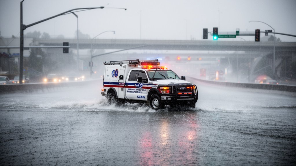
The San Francisco Bay Area is currently facing a significant meteorological event as a high-intensity atmospheric river stalls over the region, prompting urgent warnings from local and state authorities. The severe storm system, characterized by relentless rainfall and gusty winds, has transformed regional thoroughfares into channels of standing water, severely disrupting the morning commute and triggering emergency protocols across the nine-county area. As transit agencies scramble to manage delays, the California Governor’s Office of Emergency Services (Cal OES) has officially moved to a heightened state of readiness, pre-positioning swift-water rescue teams and equipment to mitigate risks to life and property.
Meteorological Profile: The Anatomy of the Atmospheric River
At the core of the current crisis is a classic atmospheric river—a long, narrow region in the atmosphere that transports water vapor outside of the tropics. The National Weather Service (NWS) has indicated that this particular system is stalling, which increases the duration of rainfall over urban centers. Unlike rapid-moving cold fronts, this phenomenon acts like a conveyor belt of moisture, dumping persistent, heavy precipitation on saturated ground. The NWS monitoring stations have reported hourly rainfall rates that are overwhelming standard municipal drainage systems, leading to rapid accumulation in low-lying areas and underpasses.
Meteorologists are emphasizing that the soil saturation level from previous winter months has left the region with little capacity to absorb additional rainfall. Consequently, runoff is reaching historic levels, turning creeks into torrents and causing street-level flooding that is catching many commuters off guard. The unpredictability of these “training” rain bands—where clouds repeatedly reform over the same location—has made the short-term forecast exceptionally volatile, requiring constant adjustments to emergency deployment strategies.
Infrastructure Under Duress: Transit and Transportation Impacts
Transportation networks across the Bay Area are experiencing the most acute symptoms of the storm. Commuter traffic on major arteries, including Highway 101 and I-80, has slowed to a crawl due to flooded lanes and decreased visibility. Caltrans crews are currently working around the clock to clear clogged storm drains, but the sheer volume of debris—ranging from tree branches to sediment—is hampering efforts to maintain drainage efficiency.
Public transit has not been spared. Bay Area Rapid Transit (BART) officials have issued advisories regarding potential delays due to track-level water intrusion and power instability. Meanwhile, ferry services, which provide a critical lifeline for cross-bay commuters, are facing significant cancellations due to high wind speeds and choppy bay conditions. The operational decisions are being made hour-by-hour, forcing tens of thousands of residents to reconsider their daily travel plans. For those reliant on public transit, the uncertainty creates a cascade of economic disruption, as employees find themselves unable to reach workplaces, and supply chains experience delays in delivery and distribution.
The State Response: Cal OES Mobilization
The scale of the storm necessitated a swift response from the California Governor’s Office of Emergency Services. By pre-positioning rescue personnel, the state is prioritizing a proactive rather than reactive stance. These specialized teams are equipped with high-water vehicles and inflatable rescue rafts, specifically trained to operate in urban flood environments. This logistical maneuver is a direct lesson learned from past flooding events, where response time was identified as the critical factor in preventing loss of life.
Coordination between the state and local agencies is occurring in real-time. Emergency Operations Centers (EOCs) have been activated in multiple counties, facilitating the rapid allocation of sandbags, pumps, and specialized lighting equipment. The focus of the state authorities is twofold: maintaining the integrity of major arterial roads for emergency vehicles and monitoring for potential slope failures in saturated hillsides, which remain a significant hazard as the storm continues.
Secondary Angle: The Urban Drainage Resilience Challenge
While the current focus is on life safety and immediate transit, the storm has reignited a critical debate regarding the adequacy of Bay Area infrastructure. Many of the region’s storm drains and culverts were designed for a different climate reality. As the frequency of extreme weather events increases, urban planners are facing the stark reality that current drainage capacity is insufficient to handle the “new normal” of intense atmospheric river events. The cost of upgrading this subterranean infrastructure is astronomical, yet the current economic impact—measured in lost productivity and emergency repairs—suggests that the long-term price of inaction may be higher.
Secondary Angle: Economic Ripple Effects and Supply Chain Vulnerability
Beyond the immediate inconvenience, the storm highlights the Bay Area’s economic vulnerability to environmental shocks. In an economy heavily reliant on just-in-time logistics, the disruption of key transit corridors acts as a bottleneck. From the micro-level of retail deliveries to the macro-level of regional logistics hubs, the storm acts as a tax on efficiency. Businesses are increasingly forced to factor “weather resilience” into their operational models, which is leading to a shift in how companies approach remote work policies and decentralized inventory management during the wet season.
Secondary Angle: The Role of Predictive Analytics
Finally, the success of this mobilization can be attributed to the advancement in meteorological predictive analytics. NOAA and NWS now utilize satellite-based observation platforms that provide higher-resolution data than ever before. This allowed agencies like Cal OES to “stage” assets before the rain even began. This predictive power is shifting the paradigm of emergency management from a state of chaotic reaction to one of calculated orchestration, where data points directly influence the deployment of human resources.
FAQ: People Also Ask
Q: What should I do if I see road flooding while driving?
A: The official guidance is simple: “Turn around, don’t drown.” Do not attempt to drive through standing water, as just six inches of fast-moving water can knock over a person, and a foot of water can sweep away most vehicles. If you encounter flooding, reverse safely and find an alternate route.
Q: How can I check for real-time transit status during the storm?
A: Passengers are encouraged to monitor the official BART website, 511.org for regional transit updates, and Caltrans QuickMap for live highway condition reports. These platforms provide the most accurate, real-time data regarding delays and service suspensions.
Q: Why is Cal OES pre-positioning teams so significant?
A: Pre-positioning assets allows first responders to be closer to potential impact zones. Instead of waiting for a 911 call and then traveling to the scene, teams are already staged nearby, allowing for response times measured in minutes rather than hours, which is critical during flash flood events.