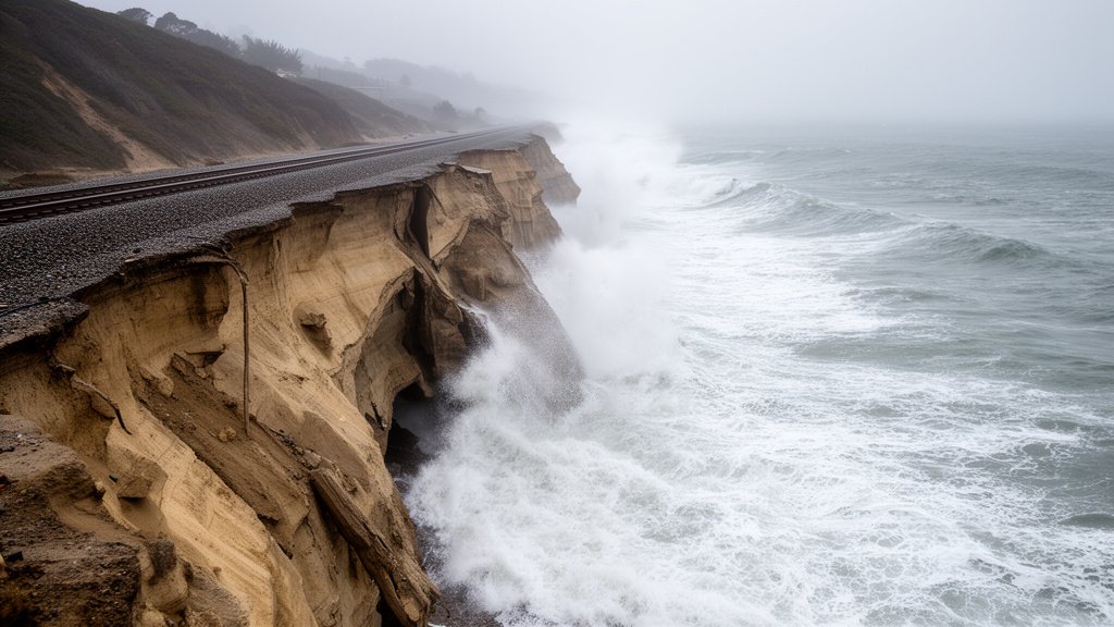
California is facing a severe El Niño-driven climate threat, with analysts from Climate X projecting between $2 billion and $3 billion in potential damages from flooding and mudslides this winter. Current beach erosion and the arrival of Kelvin waves—which have already raised sea levels by 16 inches in specific coastal pockets—are compounding the risk for coastal communities. The state is currently navigating an unprecedented convergence of environmental stressors that threaten to destabilize critical infrastructure and reshape the Pacific coastline.
Key Highlights
- Projected Economic Damage: Financial models from Climate X estimate total state damages between $2 billion and $3 billion due to flooding, landslides, and coastal erosion.
- Oceanic Triggers: The arrival of oceanic Kelvin waves has effectively raised localized sea levels by 16 inches, creating a high-tide environment that penetrates deeper into bluff bases and shoreline developments.
- Infrastructure at Risk: Coastal highways, sewage treatment facilities, and residential bluffs in regions like San Diego and Pacifica are facing immediate collapse risks.
- Climate Persistence: Unlike temporary weather events, the current El Niño cycle is being amplified by broader climate patterns, leading to sustained beach sediment loss that the coastline cannot naturally replenish in the short term.
The Anatomy of a Coastal Emergency
The current emergency facing California is not a singular event but a complex intersection of meteorological and oceanographic phenomena. While El Niño is traditionally associated with increased precipitation, the secondary effects—specifically the behavior of oceanic Kelvin waves—have proven to be the most destructive variables in the 2024-2025 climate modeling.
The Role of Kelvin Waves
Oceanic Kelvin waves are massive, wave-like disturbances in the upper layers of the ocean that move eastward along the equator. When they strike the coast of the Americas, they act as a biological and physical catalyst. In California, these waves have forced warm, buoyant water against the coastline, suppressing the natural upwelling of colder water and elevating sea levels by as much as 16 inches. This elevation is critical; it places the high-tide line significantly higher on the beach profile than historical averages. As the water reaches further up the sand, it strikes the base of coastal bluffs with increased kinetic energy, accelerating the undercutting process that leads to slope failure and landslides.
Economic Projections and Financial Impact
Climate X, a leader in climate risk assessment, has quantified the impending threat with alarming precision. The projected $2 billion to $3 billion in damages accounts for more than just immediate property loss; it encapsulates the long-term costs of infrastructure remediation. This includes the massive expense of stabilizing crumbling bluffs, reinforcing the rail corridors—which are vital to the Pacific Surfliner and freight logistics—and the potential total loss of homes teetering on the edges of cliffs.
Insurance markets are already reacting to these projections. As the risk profile of coastal real estate shifts from ‘periodic hazard’ to ‘near-certain liability,’ property premiums in vulnerable zones like Del Mar and San Clemente are expected to skyrocket. Municipalities are now tasked with the unenviable choice of paying for short-term fixes or preparing for the total managed retreat of infrastructure away from the coastline.
Regional Vulnerabilities and Infrastructure Fragility
The California coastline is far from a uniform entity; its vulnerabilities are granular and location-specific.
Southern California’s Bluff Crisis
The Southern California coastline, characterized by high-density residential developments built atop semi-consolidated sandstone bluffs, is the ‘ground zero’ of this emergency. In areas like the Del Mar bluffs, decades of erosion have been exacerbated by the current El Niño cycle. The vibration from train traffic combined with the hydrostatic pressure from record rainfall creates a recipe for structural failure. The weight of these impacts is not borne by the state alone but by a complex web of city governments and private homeowners associations (HOAs) that often find themselves under-resourced to handle the scale of remediation required.
Central and Northern Coast Exposure
Further north, the focus shifts from bluff stability to riverine flooding and sediment transport. As the El Niño cycle drives more intense atmospheric rivers into the Northern California coast, watersheds are overwhelmed. The resulting runoff does not merely flood streets; it alters the very sediment budget of the beaches. When beaches are stripped of their sand, the natural ‘buffer’ that protects against wave energy vanishes, leaving coastal towns vulnerable to severe, direct wave impact.
Historical Context and Future Forecasting
To understand the gravity of the current situation, one must look at the historical precedents of 1982-83 and 1997-98. Both were significant El Niño years that fundamentally altered the coastline. However, the current situation is distinct due to the baseline of climate change. Sea levels are higher globally than they were in 1997, meaning that the ‘bonus’ height provided by Kelvin waves is building upon a foundation that is already elevated. This ‘compounding effect’ is what keeps climate analysts at night. We are no longer dealing with a return to a known baseline; we are witnessing the creation of a new, more dangerous normal.
Predictive Analytics and Adaptation
The future of California’s coast will likely be defined by a shift from ‘defense’ to ‘resilience.’ Defensive measures like seawalls and breakwaters have historically been the go-to solution, but environmentalists argue that these structures often exacerbate erosion in neighboring areas by reflecting wave energy. The current policy landscape is trending toward nature-based solutions—such as beach nourishment (adding sand back to the beach) and the restoration of coastal wetlands—to dissipate wave energy before it hits the shore. While expensive, these methods are increasingly viewed as the only long-term viable strategy to protect the billions of dollars of assets currently in the path of the encroaching Pacific.
FAQ: People Also Ask
1. What exactly causes the 16-inch sea level rise?
It is not a global sea-level rise, but a localized ‘dynamic’ rise. The Kelvin waves push warm, less-dense water toward the California coast. Because warm water occupies more volume and the wave forces this water against the land, the sea level rises significantly and temporarily in the affected region.
2. Why is $3 billion considered a conservative estimate?
This figure primarily focuses on direct infrastructure, public works, and documented property loss. It often does not fully account for the secondary economic impacts, such as the disruption of coastal tourism, the loss of tax revenue from devalued properties, and the long-term environmental cleanup costs following mudslides.
3. Is there any way to stop the beach erosion?
While we cannot stop the weather patterns causing it, we can mitigate the damage. ‘Hard’ armoring (seawalls) is common but often destructive to the beach itself. ‘Soft’ armoring, such as placing artificial dunes or pumping sand (beach nourishment), is increasingly favored as it provides a buffer that absorbs wave energy without accelerating erosion elsewhere.
4. How long will this El Niño emergency last?
El Niño cycles typically last between 9 and 12 months, though the aftermath of the erosion can persist for several years. The ’emergency’ phase is usually the winter months (November through March), when atmospheric rivers and high tides coincide to cause the most catastrophic damage.