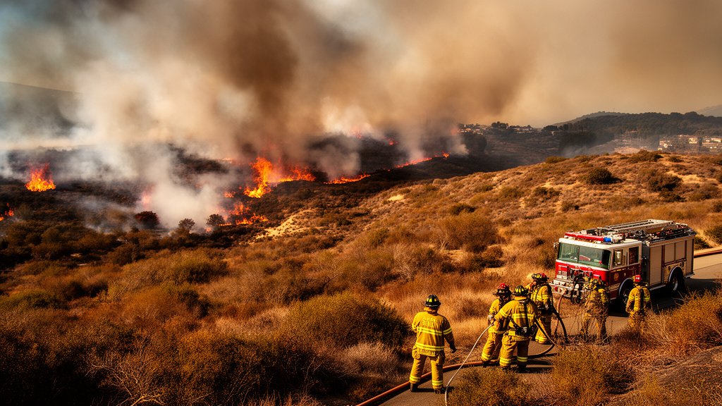
Firefighters in Southern California are currently engaged in an aggressive battle against a series of rapidly spreading wildfires as fierce Santa Ana winds whip through the region, creating near-perfect conditions for explosive fire growth. The ‘Norte Fire’ in Orange County, which has already consumed nearly 500 acres, serves as the focal point of a volatile situation that is now straining emergency resources across several counties. As gusts continue to push the blazes toward populated areas, including San Clemente and San Juan Capistrano, local authorities are on high alert, managing a complex tactical environment that extends from the coast to federal military lands.
Key Highlights
- Norte Fire Expansion: The blaze in Orange County has reached 500 acres, placing significant pressure on containment lines near San Clemente and San Juan Capistrano.
- Multiple Fronts: Beyond the Norte Fire, active blazes are currently being suppressed in Malibu and within the borders of Camp Pendleton.
- Meteorological Threat: Persistent, high-velocity Santa Ana winds are the primary driver of current fire behavior, creating rapid ‘spotting’ where embers travel ahead of the main fire front.
- Regional Readiness: CAL FIRE and the Orange County Fire Authority (OCFA) have deployed aerial and ground assets to the Wildland-Urban Interface (WUI) to mitigate the threat to residential infrastructure.
Escalating Risks: The Battle Across Southern California
The Norte Fire and the Orange County Threat
The Norte Fire, currently the most pressing concern for Orange County emergency response units, has demonstrated a rapid rate of spread, typical of vegetation fires during Santa Ana wind events. The terrain in this area—often characterized by dense, dry chaparral—provides ample fuel for the flames. Firefighters are contending with shifting wind directions, which complicate the establishment of firebreaks and the deployment of containment lines. The proximity of this blaze to San Clemente and San Juan Capistrano has prompted authorities to prioritize the protection of residential corridors, with evacuation protocols updated in real-time based on fire progression data.
Meteorology: The Santa Ana Catalyst
The intensity of the current fire activity is directly linked to the Santa Ana wind phenomenon. These katabatic winds originate in the high-pressure systems over the Great Basin, rushing down through the mountain passes of Southern California. As the air descends, it compresses and warms, leading to extreme drying of local vegetation. When these winds align with already parched brush, the fuel moisture levels drop to critical thresholds. In this specific event, wind gusts have been clocked at speeds that carry embers over existing containment lines, a process meteorologists call ‘spotting,’ which can initiate new, independent fires miles ahead of the primary blaze. This dynamic makes standard containment strategies significantly more difficult, forcing incident commanders to pivot to defensive positions repeatedly.
Malibu and Camp Pendleton: A Distributed Crisis
While the Norte Fire dominates the headlines in Orange County, the broader Southern California landscape is experiencing a distributed crisis. Reports from Malibu indicate that emergency crews are actively managing fire activity that threatens coastal infrastructure, a perennial challenge in that region given its narrow access points and high-value property concentration. Simultaneously, fire activity on Camp Pendleton adds a layer of federal coordination to the response efforts. Military installations present unique challenges, including the presence of unexploded ordnance in some training ranges and the necessity of coordinating military assets with civilian CAL FIRE command structures.
The Wildland-Urban Interface (WUI) Challenge
The current situation underscores the increasing volatility of the Wildland-Urban Interface—the zone where human development meets undeveloped wildland. As Southern California’s sprawl continues, more homes are situated in high-fire-severity zones. The current blazes are testing the resilience of modern defensive strategies, including home hardening (using fire-resistant building materials) and defensible space clearing. Experts note that while these measures can mitigate damage, the sheer velocity of Santa Ana-driven fires often outpaces defensive capabilities, emphasizing the need for robust early warning systems and efficient evacuation infrastructure.
Economic and Insurance Implications
Beyond the immediate physical danger, these fire events carry significant long-term economic consequences. The frequency of these autumn fire events has caused a crisis in the regional homeowners’ insurance market. Many providers have limited their exposure or withdrawn from high-risk areas entirely, leaving homeowners to rely on the FAIR Plan (Fair Access to Insurance Requirements). Each incident, like the current wave of fires, serves to recalibrate risk models, potentially leading to increased premiums and a reevaluation of development viability in specific topographic regions. Policy experts are now watching closely to see how the state handles potential claims arising from the current destruction.
Advancements in Fire Suppression Technology
Despite the severity of the winds, firefighting tactics have evolved. Incident commanders are increasingly utilizing satellite-based infrared mapping and real-time drone reconnaissance to monitor fire perimeters. These technologies allow for dynamic resource allocation, ensuring that ground crews are deployed to the most critical ‘hot spots’ rather than spread thinly across a massive front. Furthermore, the coordination between local fire departments, CAL FIRE, and federal agencies like the US Forest Service has become more streamlined, with automated mutual aid agreements ensuring that the nearest available resources—regardless of jurisdictional boundaries—are dispatched to the scene.
FAQ: People Also Ask
1. What is causing the current fire spread in Southern California?
The primary driver is the Santa Ana winds, which are strong, dry, downslope winds that significantly dry out vegetation and cause fire embers to travel long distances, sparking new fires.
2. Which specific areas are currently being threatened by the Norte Fire?
The Norte Fire is actively threatening areas surrounding San Clemente and San Juan Capistrano in Orange County, with emergency crews focusing on protecting residential structures in those vicinities.
3. How do fire authorities manage fires on military bases like Camp Pendleton?
Fire suppression on Camp Pendleton involves a coordinated effort between military fire departments and civilian agencies like CAL FIRE. They must manage the risks of the fire itself while also considering the specific geography of military training ranges, which may have restricted access or safety hazards.
4. What should residents in affected areas do to prepare?
Residents are advised to monitor local emergency alerts, maintain a ‘go-bag’ with essential documents and supplies, and ensure that all defensible space around their property—clearing brush and flammable material—is maintained to maximize the chance of structure survival.
5. Why are these fires so difficult to contain?
The combination of steep, rugged terrain, high-velocity wind gusts that inhibit aircraft operations, and extremely low fuel moisture levels makes these fires particularly difficult to contain. The wind often creates ‘spot fires’ far ahead of the main front, forcing firefighters to continuously re-establish containment lines.